
The Arctic Circle covers approximately 5.5 million square miles over several countries at the farthest north of our planet, and has a landscape of glaciers, icebergs, sea ice, and permafrost. But it also has some unique facts you may not know.
1. The position of the Arctic Circle moves every year
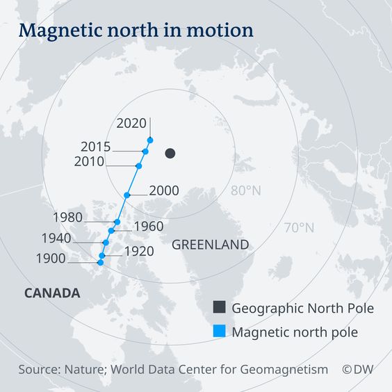
The Arctic Circle is located approximately 66.3 degrees north of the equator, but its actual location varies every year due to the fluctuation of Earth’s axial tilt, which is influenced by the orbit of the moon and the consequent tidal changes. This is known as “polar drift.” Right now, the circle is moving north at a rate of about 49 feet per year, heading toward Russia.
2.
Polar bears are unique
to the Arctic region
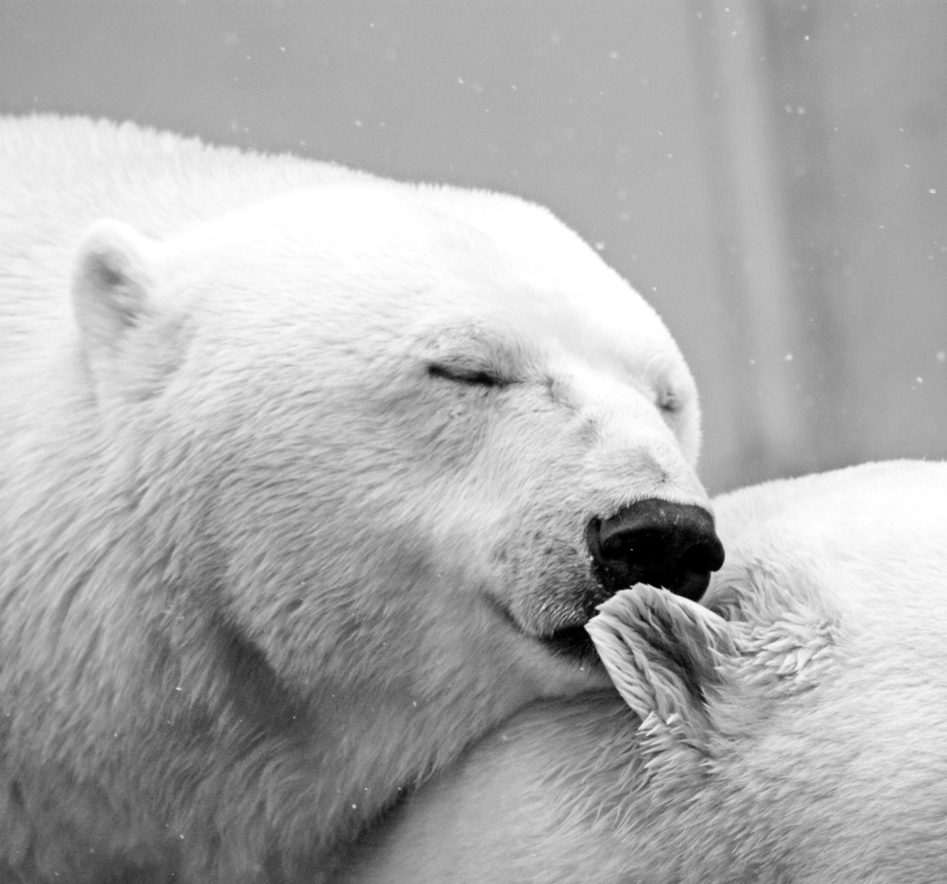
Polar bears are the largest land carnivores in the world and are only found in the Arctic. They are dependent on sea ice for food, to rest, and to breed. Fully grown males stand around 8 to 9 feet from noseto toe, while females are approximately 6 to 7 feet, and yet at birth, they are only about the size of an adult guinea pig. They feed mainly on seals, are great swimmers, and their white fur coat camouflages them in their snowy surroundings.
3. The term “arctic” is a
Greek reference for “bear”
The word “arctic” itself is derived from the Greek word arktos, which means “bear.” However, the bear reference isn’t of the polar kind, but of the celestial: Ursa Major (Great Bear) and Ursa Minor (Little Bear) constellations. Both of the constellations are visible from the Northern Hemisphere, and Ursa Minor contains the North Star. At the opposite end of the Earth, Antarctica also gets its name from the Greeks, meaning “opposite of the Arctic,” and it so happens that there are no bears in Antarctica.

4. More than 4 million people live in the Arctic Circle
The Arctic Circle incorporates portions of eight countries: Canada, Greenland, Iceland, Norway, Finland, Russia, Sweden, and the United States. Despite the harsh climate, an estimated 4 million people live and work in this area year round. Murmansk, in north-western Russia, is the largest and one of the oldest settlements in the Arctic Circle. This city on the Barents Sea is home to around 300,000 residents and is known for its seaports and naval bases. In fact, eight of the 10 largest Arctic settlements are located in Russia.
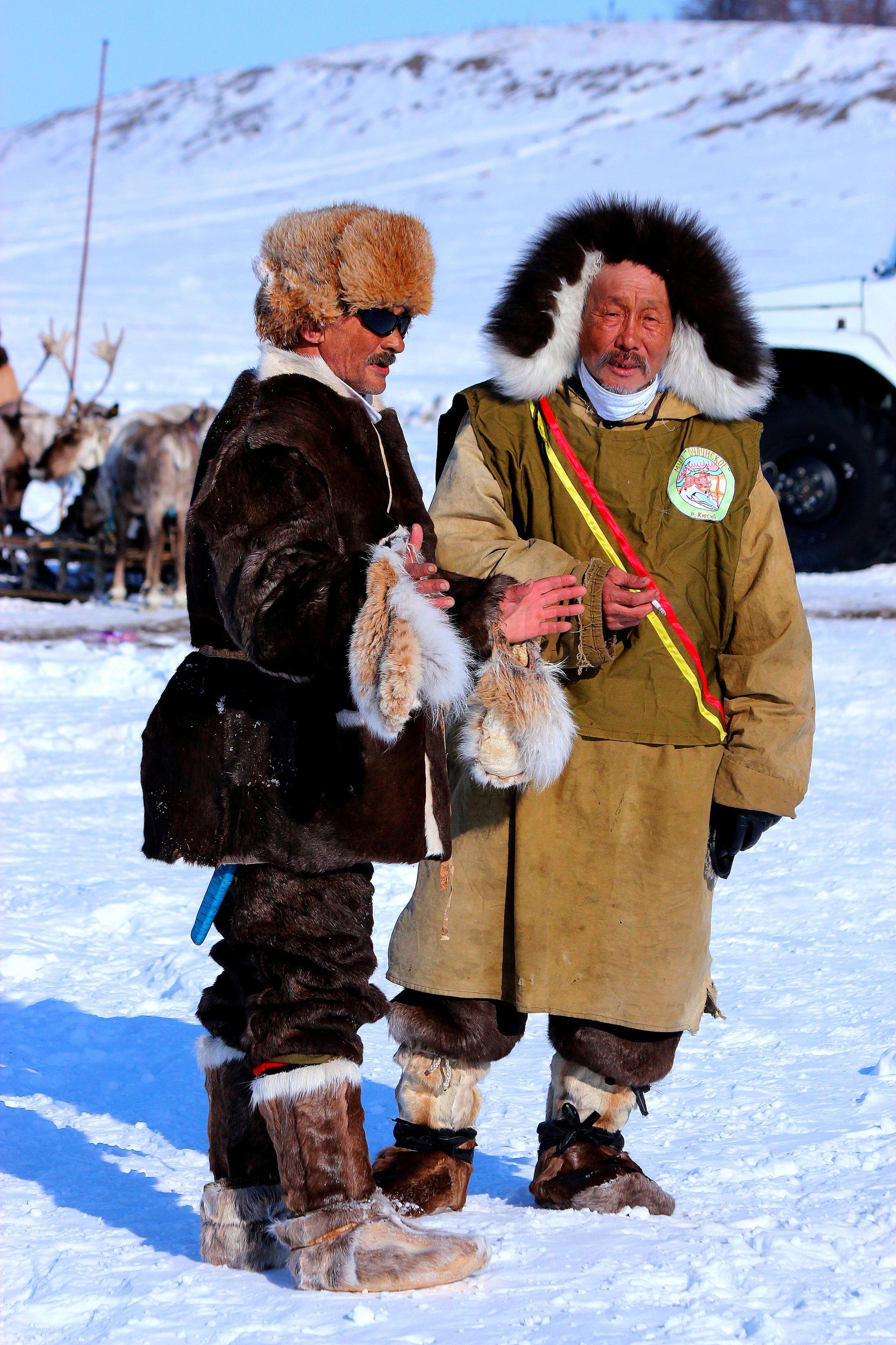
5. Many indigenous groups live in the Arctic Circle
More than 40 different ethnic groups occupy the Arctic Circle including the Inuit (northern regions of Canada), Sami (Norway, Finland, Sweden), and Yupik (Siberia) tribes, accounting for 10% of the regional population. While they vary greatly in culture, language, and history, these groups have a strong connection to the land they’ve inhabited for thousands of years: traditional fishing, reindeer herding, and hunting. That said, their livelihoods and productivity are currently under threat from
dramatic weather changes and disappearing sea ice.

6. The Arctic Circle maintains the largest seed “library” in the world
In 2008, the Norwegian government opened the Global Seed Vault in Svalbard, the world’s largest secure seed storage, in case of crop failures or natural disasters. It is buried almost entirely into the island’s permafrost (only the concrete entrance is visible), and only scientists and staff are allowed inside. The structure has the capacity to store more than 4,000 plant species and contains 1.5 million different seed samples sealed in airtight aluminum bags. Its temperature stays around 39.2°F, and the building is designed to last infinitely. The vault is built 426.5 feet into rock and above sea level so that it is protected against external hazards and climate change effects.
7. Four U.S. national park sites are located in the Arctic Circle
Alaska is home to 54 million acres of land protected under the U.S. National Park Service, representing about two thirds of land in the Arctic region. Four of the state’s national parks are situated inside the Arctic Circle: Cape Krusentern National Monument, Gates of the Arctic National Park and Reserve, Kobuk Valley National Park, and Noatak National Preserve. Visitors can discover the untamed wilderness, glaciated valleys, rivers, and lagoons framed by soaring mountain ranges. There are also opportunities to spot caribou and grizzly bears and experience days of extreme daylight and darkness at certain times of the year.

8. There are 4 North Poles
in the Arctic Circle
For many, the North Pole is often associated with Santa Claus, flying reindeer, and toy-making elves. What most don’t know is that there are actually
- The Geographical North Pole (aka True North) is the northernmost point on the planet and where all of Earth’s lines of longitude meet.
- The Magnetic North Pole is the spot at which the planet’s lines of magnetic force all point vertically downward (and the point that attracts the needle of a compass).
- The Geomagnetic North Pole is the northern end of where the axis of the magnetosphere —the magnetic field that surrounds the Earth and extends into space — intersects the planet.
- The Arctic Pole of Inaccessibility, 85°48′N 176°9′W, is the point in the Arctic Ocean that’s furthest from any coastline: It is equidistant from the Ellesmere, Komsomolets and Genriyetta (Henrietta) islands. Modern satellite data has confirmed that distance to be 626mi. As this blog states, there are many other “poles of inaccessibility” throughout the world, and their common thread is that they are extremely inaccessible.
9. A cartoonist invented Santa’s North Pole as his home
German-born American caricaturist
and editorial/political cartoonist Thomas
Nast is best known for the creation of
the
modern-day Santa Claus. In 1863, Harper’s Weekly magazine published
his illustrations that depicted Santa
as a larger-than-life character with a
long beard and stocking cap. One of the
images was inscribed with the words
“Santa Clausville, N.P.”
The N.P. was an abbreviation of North Pole: Santa’s workshop and residence — geographically isolated, politically neutral, and a natural tie-in to reindeer and snow. The Pole had been in the news intermittently for two decades — since British Admiral Sir
John Franklin’s
ill-fated 1845 Arctic expedition — so the Weekly’s audience could readily relate to it.